
“An individual measurement involves driving out to a well, opening up the well, dropping a tape in it, recording that measurement, and then quality assuring that measurement and placing it into our database,” Cunningham says. And although wells that use telemetry require less manpower, check-up visits are still necessary.
|
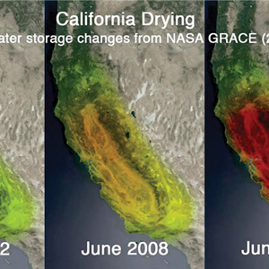
| GRACE satellites have documented stark changes in water storage in California since their launch. Source: NASA/JPL-Caltech/University of California, Irvine |
Now a new, top-down way of measuring groundwater is progressing with the help of two Gravity Recovery and Climate Experiment (GRACE) satellites. Launched in 2002, the pair circle the globe recording changes in Earth’s gravity field every month. They’re able to track water mass change, including that of groundwater, at large scales of 150,000 square kilometers and greater.
The GRACE mission is a collaboration between NASA and the German Aerospace Center (DLR). The satellites are managed by the Jet Propulsion Laboratory in Pasadena, Calif.
One of the mission’s most recent contributions takes the form of a 2014 study by NASA and scientists from the University of California, Irvine. Using GRACE satellite data, the team found that more than 75 percent of the water loss in the Colorado River Basin since 2004 came from groundwater resources.
Jay Famiglietti, senior water scientist at NASA’s Jet Propulsion Laboratory, was a part of the research team that led the study. Also an earth system science professor at the University of California, Irvine, he’s been partnering with the Jet Propulsion Laboratory since before the satellites were launched.
“It’s revolutionary. I think it’s really changed the way that we think about global groundwater,” he says. “I think it’s awareness that this is a huge problem. It’s not just move the drill over 100 feet or a quarter of a mile or, you know, five miles. This is a regional and global problem.”
Famiglietti hasn’t always had such confidence in the mission. Back in the ’90s, when a team of colleagues at the University of Texas started talking up its potential to track groundwater storage changes, he didn’t think they knew what they were talking about. “I didn’t believe it … and so we kind of dug in.”
Now, nearly 20 years later, his team has completed groundwater storage studies and papers on areas including India, the Middle East and California’s Central Valley, in addition to the Colorado River basin.
GRACE isn’t limited to measuring changes in groundwater though. The change in the gravity field every month, due to mass moving around on Earth, is almost entirely water in some form or another. GRACE measures changes in groundwater, polar ice caps, surface water and soil moisture. “You might think of it as where the water is every month,” says Michael Watkins, manager of the science division at the Jet Propulsion Laboratory.
Watkins was a part of the group that came up with the idea to create GRACE and he says a very small team of scientists at the Jet Propulsion Laboratory, the University of Texas and in Germany master instrumentation operations, data analysis and data processing for the mission. They convert the raw data from GRACE into usable data for scientists like Famiglietti. “It’s really only less than a dozen people really keeping the mission going and doing the first level analysis of the data,” he says.
Figuring out groundwater change involves simple math, according to Famiglietti. “We’ll put together the data sets of how much of the storage change is snow and how much is coming from reservoirs and water in rivers and how much is coming from moisture in the soil, and we subtract those from the GRACE data and that gives us the groundwater.”
The data obtained from the satellites is in equivalent water height initially, and then processed into volume. The data is generally extremely solid, Famiglietti says. They compare it to federal and state well observations and they use a water balance equation (change in storage over time in precipitation, minus evaporation, minus run-off) to validate it.
“It’s state of the art, it’s the first of its kind, it’s showing people something that they weren’t able to know any other way until now,” says Stephanie Castle, water resource specialist and lead author of the Colorado River study. “It’s really the first way that, on a large scale, can tell us how groundwater storage is changing …”
But Cunningham, who says seeing regional mass changes from space is cool, isn’t so excited about the mission. That’s not to say he isn’t fond of its accomplishments and potential. He says it just doesn’t really impact USGS. “I think it’s complementary, but certainly it’s of limited value from a management standpoint because most management issues are at the state or local level.”
That’s a point that Famiglietti stresses as well. The goal, he says, is not to replace USGS methods. From his perspective as a hydrologist, he says, having a robust ground base for tracking groundwater measurements is key.
“It’s not that [GRACE is] better,” he says. “It’s just different. You can look at whole regions; you can get this picture of what’s happening with water storage. … So, of course, you have to use the two hand-in-hand, but it’s extremely complementary.”
The very asset the GRACE team prides itself on — tracking regional water storage changes and offering large-scale trends — is a weakness in terms of water management. “So, of course, we want to, we call it downscaling, because we want to get to a higher resolution,” says Famiglietti. This would make the data more useful and comprehensible for local and state officials charged with regulating groundwater.
Another limitation is that, unlike USGS, GRACE isn’t capable of offering real time groundwater measurements; only monthly groundwater storage changes. “The kicker is we don’t know how much water is left in the aquifers,” Castle says. “We don’t know how much [groundwater] was there to begin with. It’s a very difficult thing to measure. The GRACE satellite can’t tell us that …”
While actual groundwater measurements aren’t possible, Watkins says getting closer to real time measurements is. They’ve experimented with a faster data turnaround project at the University of Texas, which can make water storage change data available one to two weeks later. “But it’s not quite as accurate because it takes us a month to get the very best answer, but we get a quick snapshot that’s not quite as accurate within a week or two.”
Getting the satellites to track groundwater storage change over tighter areas than the current 150,000 square kilometers and greater is the biggest challenge right now, according to Watkins. He says a new laser technology that could retrieve the data at higher resolutions is being tested. It could make its debut as soon as 2017, when a GRACE follow-on mission using two new satellites is set to launch.
For Famiglietti, improving GRACE to better influence water management is a top priority.
“Ultimately I think we want to combine them all — the ground base data, the satellite data and aircraft data — into a computer model, say of the hydrology of California at high resolution. In our field that’s the future, is combining all that into a model so we can better understand how water’s moving around and better predict how it’s going to change in the future.”
Valerie King is associate editor of National Driller.


Report Abusive Comment